Alex Patia is a birder and naturalist who works for Teton Science Schools as a wildlife guide. He lives in Jackson with his husky, Mia.
It’s no secret that winter in Jackson Hole is harsh for wildlife. Many animals migrate out of the area to avoid the deep snow and frigid subzero temps that occur here. You likely know about some of our more charismatic mammals that tough out the winter here, like the elk and bighorn sheep on the National Elk Refuge, but many bird species also stay for the winter. If you don’t normally pay much attention to birds you could be forgiven for thinking that ravens and magpies are the only birds that stick around for winter, they are certainly some of the most abundant and conspicuous winter residents we have!
Even if you are looking for birds in winter you’ll likely only encounter 10-30 species in a day around Jackson. Given how hard it can be to find many birds in winter it may surprise you to find out that 80 species of birds can be found in Teton County, Wyoming every winter. I have put together a list of these 80 bird species and how likely you are to encounter them as well as a list of 40 additional species that have been documented in Teton County but do not normally occur most winters. In this post I want to tell you about some of these fascinating species, their adaptations for surviving the cold, and what you can do to help the birds!
I could tell you about all 80 species of birds that reside in Teton County, Wyoming for winter, but that would require writing a book, so instead I want to highlight some winter birds that can be found right in your backyard. Specifically, I am choosing to discuss birds that will readily come to check out bird feeders and offer nice views vs. species that hide in dense forests all winter. Ravens and Black-billed Magpies may be the easiest corvids to see but if you live in an area within or near forest you may be treated to other members of this bird family including Clark’s Nutcrackers, Steller’s Jays, and Canada Jays. These three corvids breed high in the mountains but in winter they will move to lower elevations and may even visit your bird feeders! In milder winters Jackson Hole can also get Blue Jays, very different from their cousin Steller’s Jays with paler blue backs, white underside, and no black crest.
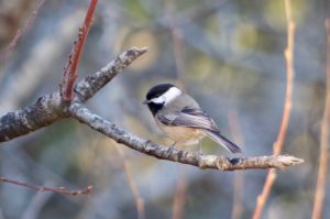
Black-capped Chickadee by Alex Patia
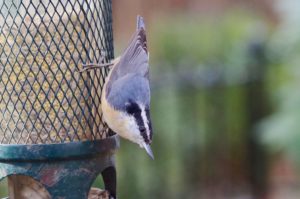
There are two families of small forest dwelling birds that are likely familiar because of how curious they can be around humans and how objectively cute they are: chickadees and nuthatches. Our two chickadee species are Black-capped and Mountain Chickadees, commonly seen year round but more often in small flocks in winter. Both have black heads and pale gray bodies but the Mountain Chickadee has a distinct white eyebrow that is slanted enough to give them an adorably angry expression. Black-capped Chickadees give the familiar “chicka-dee-dee-dee” call that is typically an alarm call to warn all small birds. The greater the danger the more “dee”s they will add. Nuthatches are skilled at climbing tree bark and will go in any direction, oftentimes going down headfirst or even hanging upside down. The Red-breasted Nuthatch is more common than it’s much larger cousin the White-breasted Nuthatch but both will readily visit feeders. These birds are well named because the best way to tell them apart is indeed the color of the breast.
In much of the lower 48 states winter is the best time to see native sparrows at backyard bird feeders… but not in Jackson. Even the hardy sparrow Dark-eyed Junco, a sign of winter affectionately referred to as “snow birds” in the eastern US, only winter in small numbers here in Jackson Hole. But what we lack in sparrow diversity in winter we make up for with finches! Many of our winter finch species can be found year round here, but some like Black Rosy Finches, Evening Grosbeaks, and Pine Grosbeaks spend most of the year high in the Tetons and only descend to Jackson occasionally in winter. The most familiar and abundant backyard finches are House Finches and American Goldfinches, both of which are generally most commonly seen in town, especially in winter, as they do quite well in urban environments.
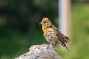
Cassin’s Finches look somewhat similar to House Finches but with a thinner bill, pink color on males, and thin crisp streaks rather than wide blurry streaks on the females. Pine Siskins, a smaller and less yellow cousin of the American Goldfinch, can form huge flocks in winter and will make themselves known with their loud “zeeeeeee” calls. Red Crossbills are common year round but unlike other finches they will rarely visit feeders, instead preferring to use their specialized bills to open the cones of specific conifer trees.
Bathing Red Crossbill by Alex Patia
Here in Jackson Hole we primarily have type 5 or Lodgepole Red Crossbills that have bills just the right size for opening Lodgepole pine cones. They will also feed on Douglas fir and Engelmann spruce cones. White-winged Crossbills are much more seldom seen, as they are a more irruptive species, meaning they may venture south or to lower elevations in huge flocks some years but will be notably absent other winters.
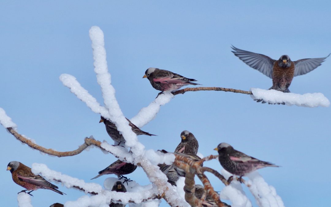
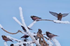
Evening Grosbeaks, a giant yellow finch with black wings and tail, are similarly irruptive and highly nomadic moving around throughout the winter. If you see Evening Grosbeaks in your yard count yourself lucky and savor the moment! Also highly nomadic are the Gray-crowned and Black Rosy Finches. Gray-crowned Rosy Finches are strictly a winter visitor to Jackson Hole as they breed in mountain ranges closer to the Pacific coast from the Sierra Nevada and north to the tundra of Alaska. Black Rosy Finches breed in the high alpine of a few isolated locations around the interior West including the Tetons.
Rosy Finches by Alex Patia
One adaptation Rosy Finches have for frigid nights is roosting in large communal flocks inside caves, rock crevices, barns, and old Cliff Swallow nests! Every couple of years Common Redpolls will appear, often among large flocks of Pine Siskins to which they look similar save for a stubby yellow bill, namesake red cap, and pinkish breast on males.
Lastly, if you are very very lucky you may have my favorite finch visit your yard: the Pine Grosbeak. This is a truly giant finch with bright red head and breast on males and a more subdued but still beautiful yellow head and gray body on females. Pine Grosbeaks spend most of their year in subalpine forests but will come to lower elevations in winter to visit feeders or like Cedar and Bohemian Waxwings they will feed on lingering fruit in hawthorns or ornamental cherry trees.
If you are wanting to attract birds to your yard and help improve their survival through the cold, harsh winter you only need three things: food, shelter, and water. You may think that you’ll need a heated birdbath to supply birds with an ice-free water source, but most birds will readily eat snow as a water source. So, you really only need two things: food and shelter. If you have any large native trees or dense shrubs you not only have shelter but also food in the form of hibernating insects in the bark and seeds in trees. You can supplement bird’s normal diet by putting out bird feeders but there are a few things you should consider with any bird feeder setup. If you’re not wanting to feed or attract rodents the feeders will need to be hanging from a pole more than ten feet from the nearest trees or branches and with a baffle or metal cone about halfway up the pole so rodents cannot climb up.
Red-breasted Nuthatch, a common visitor to backyard feeders, by Alex Patia
The feeders should also be high enough up that a bear cannot reach them, especially if you intend to feed the birds outside of winter. And for the sake of the bird’s health please, please clean your feeders! If you never clean your feeders birds will get sick as a result by spreading diseases like salmonella (usually spread by lethargic Pine Siskins) and conjunctivitis (spread by House Finches with swollen eyes) especially if bird droppings are allowed to accumulate.
There is a very easy way to avoid your feeders become ground zero for a bird pandemic though, simply use bleach water or hot soapy water to clean them (a brush with a long handle is great for getting inside the feeder), rinse thoroughly afterwards, and let them dry completely before placing back outside. Try to only put out enough birdseed that will get eaten in a week or less to minimize mold and bacteria growth on the food, and then you can simply clean the feeders between filling them. I recommend feeding nyjer, black oil sunflower seeds, and suet. Avoid seed mixes with milo and millet as most native birds don’t eat these, but rodents and invasive European Starlings and House Sparrows will! If you follow these tips your feeders should stay pest and disease free!
As you may know, the February challenge for Nature Mapping is to report finches. Because most finches are so irruptive with huge fluctuations in movements, range, and population size year-to-year any and all data on when and where they do occur can be incredibly useful to better understand their changing populations. Hopefully, with this list of common winter backyard birds you will feel confident in spotting and reporting the feathered friends visiting your backyard this winter.
As wildlife conservation professionals, we remind ourselves to celebrate the successes. Sometimes we get so wrapped into understanding and mitigating the challenges facing wildlife that we feel frustrated. In these moments, it is sometimes in our best interest, our community’s best interest, and the best interest of the ecosystem to also tally up and celebrate the successes we have achieved. By doing so, we rediscover the wind in our sails. By sharing our observations of our successes, we hope to provide inspiration for our colleagues and friends (all of you!) to continue your conservation efforts!
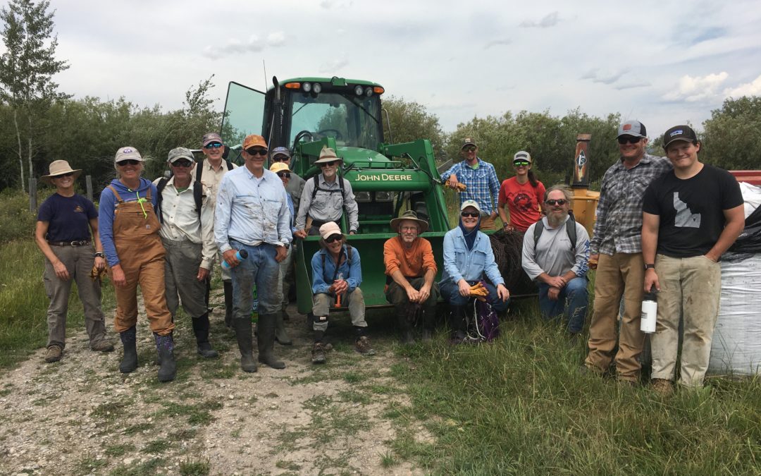
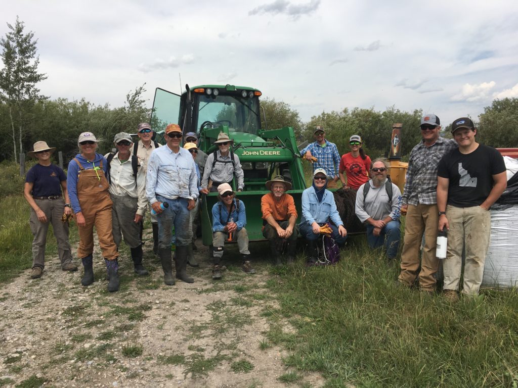
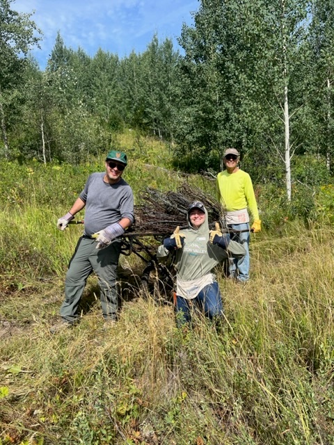
Volunteers after a successful fence pull in Teton Valley. We scheduled 8 public fence project this year, each taking plenty of time and effort to pull off!
We are happy to recognize a list of recent achievements that we and our colleagues have made happen. Did you follow the hard work that the County did to update the Wildlife Feeding Land Development Regulation (LDR) this spring? Did you know that the LDR does not include land in the Town of Jackson? Jackson manages wildlife feeding concerns separately from the County and they have embarked on discussions about their Wildlife Feeding Ordinance.
At a recent Town Council meeting, staff and Council members were unanimously in favor of improving the language in the ordinance to provide better security for bears and other wildlife. Councilman Rooks aptly summed up the sentiment in the meeting, “We are blessed to live in bear country and we need to act like it.” The Town will go through two more iterations of reviewing the ordinance language before they approve tighter restrictions on wildlife feeding, whether intentional or not.
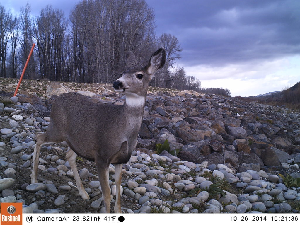
A mule deer uses one of our “levee ramps” to avoid dangerous riprap and access the river.
Do you remember when JHWF installed ‘wildlife ramps’ on the Snake River levee? That project fledged circa 2013 under the leadership of Greg Griffith with help from Gene Linn from the nearby Linn Ranch. The goal was to make it easier for all wildlife, but especially hooved animals, to access the river by giving them a path though riprap (large, uneven rocks) in which an ungulate could easily break a leg. Three ramps were built and trail cameras immediately captured images of elk, moose, deer, and even coyotes drawn to this new, preferred access to the Snake River.
This summer we worked the with Teton Conservation District to install additional wildlife ramps along the levee system near the Wilson Bridge. The additional ramps augmenting the impact of the existing ramps by increasing the number of easy access locations on the many miles of riprap along the levee Our trail cameras are currently in place, collecting images of wildlife using the ramps. We can’t wait to show you what we’ve found!
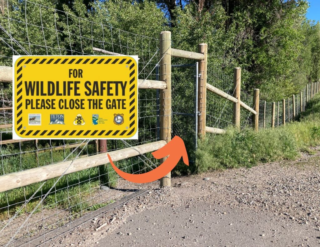
You can help keep wildlife off the highway by keeping the pedestrian gates closed!
Another win for wildlife in our community has been the system of exclusionary fencing and wildlife underpasses on S. Hwy 89, between Melody Ranch and Hoback Junction. Preliminary data has already shown a reduction in wildlife-vehicle collisions (especially involving mule deer) as animals are learning to use the underpasses to move beneath the roadway.
Last month, we worked with our partners at WYDOT, Teton Conservation District, Wyoming Game and Fish and Teton County to design, order, and install signage on the many pedestiran gates along this stretch of roadway. When these gates are accidentally left open, wildlife are able to access the highway instead of being funneled by the fencing to the underpasses. Ensuring the gates stay closed is important in order to allow the fencing and underpass system to do its job moving forward.
Of course, there are staffing successes to report too!
Charlie on the Mosquito Creek fence pull
We can’t say enough about the work ethic and positive attitude of our summer intern Charlie Brandin. Charlie played such an important role supporting our bird-banding team in action this summer. She also eagerly pitched in on several fence pulls and helped us collect data on existing fences in Grand Teton National Park as part of a major fence inventory project we’re undertaking with both the Park and Bridger-Teton National Forest.
While Charlie recently departed to begin her junior year of college on the East Coast, we are now looking forward to filling a new, full-time position of “BearWise Jackson Hole Program Manager.” This position will allow JHWF and our BearWise Jackson Hole partners to better address the persistence of human-bear conflict here in Teton County. Our goal is to have the new Program Manager out in the field helping to reduce conflicts by mid-November!
In recognition of all of this and more, won’t you join us in celebration?
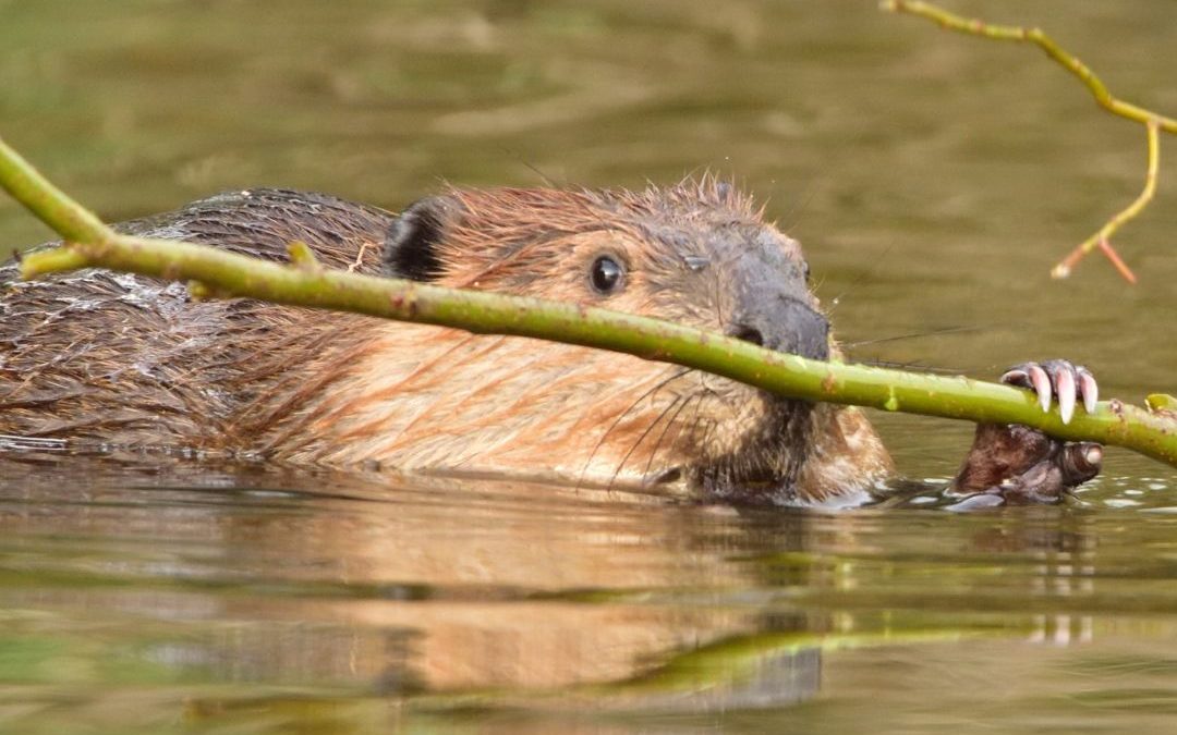
Jackson Hole Wildlife Foundation is excited to announce a new partnership with beaver researcher and hydrologist Jeff Burrell and a new project for interested Nature Mappers – Beaver Project! In Beaver Project, Nature Mappers will provide information about beaver sign they detect on the landscape in the Jackson Hole area. Read on for more information about Beaver Project from Jeff:
It is well documented that beavers provide a wide range of ecosystem services including benefits for water quality, water quantity, and fish and wildlife habitat. Beavers also make ecosystems more resilient to the impacts of climate change. These benefits include reducing peak stream flows, and so limiting erosion and damaging flashfloods; improving drought resilience and increasing ecologically beneficial natural water storage; stabilizing water temperatures; and creating/maintaining fire breaks and refugia from fires.
“More than ever, we need beavers doing what they do so well, but they need our help. Information provided by citizen scientists will help wildlife managers understand where beavers are on the landscape and what services they are providing. In Beaver Project we will gather this information by a simple process of field surveys and observations. Beavers leave behind a record of where they are or were active, and what they are or were doing. So not only can we learn about where they are now but where they were active in past. This will help us understand trends in beaver activities so federal and state agencies as well as private landowners can take actions to help ensure beaver conservation and restoration.”
Beaver Project Protocol:
Email hilary@jhwildlife.org to be added to Beaver Project in your Nature Mapping account. Not a trained Nature Mapper? Email hilary@jhwildlife.org to sign up for the August 24th training.
While out hiking along creeks, check waterways for beaver sign. If you see sign on the landscape, please consider Nature Mapping it.
If you see a live beaver, please use Casual Observations, rather than Beaver Project to document the sighting. Beaver Project is for sign only. If you observed a live beaver and beaver sign, you can indicate the live beaver in the notes section of the Beaver Project form.
Beaver activity indicators are conveniently grouped into the following categories. Because many beaver activity indicator persist through time, we can also group activities into current activities (within the past few months, recent activities (within the past year or two, or past activities (more than two years old).
Please view Jeff’s Beaver Sign Identification Seminar on our YouTube channel for more information.
In Nature Mapping Jackson Hole’s Beaver Project, check the boxes of all activity indicators you observe on the landscape, and their ages.
1. Clipping and girdling:
Beavers are famous for chewing wood to gather food and building materials. As they do so, beavers leave distinctive patterns of tooth marks. ‘Clipping’ means that the beaver directly chewed through the wood; ‘girdling’ means that the beaver partially chewed through the wood and then let wind and gravity do the rest.
Current: the wood has a fresh appearance (fresh wood color with sharp tooth marks)
Recent: the wood has changed to a darker color but still retains sharp markings
Past: the wood is much darker and more weathered in appearance with cracks and feathered markings
2. Food rafts, caches and feeding stations:
Beaver gather and store branches to eat (now or later). These branches will have the characteristic tooth marks of clipping and girdling, and can be grouped into age categories in the same fashion as clipping and girdling.
3. Slides:
Beavers move branches from harvest location to ponds and streams. To do so they pull the material into the water; these activities leave behind a smooth ramp in the mud adjacent to the pond or stream. These ramps are ‘beaver slides.’
Current: the slide is very smooth in appearance with few if any other animal tracks
Recent: the slide is still somewhat smooth but will likely show other animal tracks
Past: hard to distinguish between a beaver slide and animal path, but the location will help identity as a beaver slide
4. Bank dens, bank lodges and free-standing lodges
A bank den is a simple home burrowed into the stream or river bank. A bank lodge is similar to a bank den but has been reinforced by beavers building a dome of branches and mud above the burrow. A free-standing lodge is a pile of branches reinforced with mud within the pond.
Bank den: current (fresh, maintained appearance with current clipping around the entrance, recent (similar but the entrance will show some degradation and only recent clippings, past (very degraded and likely at least partially collapsed.
Bank lodge: see above but now we can use appearance of reinforcing branches and mud to categorize as current, recent and past
Free-standing lodge: current (current clipping and fresh mud piled on top of branches, recent (recent clipping and mud at least partially washed away, past (past clipping and most if not all mud washed away
5. Scent mounds:
Beaver use piles of debris (leaves and twigs) and castoreum (a glandular scent) to mark territories.
Current: fresh leave and twig appearance and scent
Recent: appearance more weathered and little if any scent
Past: likely not identifiable as a scent mound
6. Tracks and scat:
These are the most ephemeral of the indicators we will use. Mainly note if observed
Current: fresh appearance
Recent: degraded appearance
Past: unlikely to be identified
7. Canals:
Beavers excavate canals from the channel or pond to provide safe access to food resources.
Current: sharp boundaries with little vegetation overgrowth
Recent: boundaries less distinct with some vegetation over growth and partial collapse
Past: substantial over growth and collapse
8. Dams:
Since dams are for the most part constructed from branches and mud, use appearance of these
Current: fresh cut branches and mud
Recent: recent branch appearance and mud partially washed away
Past: past branch appearance and mud mostly gone
Thank you for your contributions to this important data set. We look forward to understanding more about beaver distribution in Jackson Hole from our partnership with Jeff!
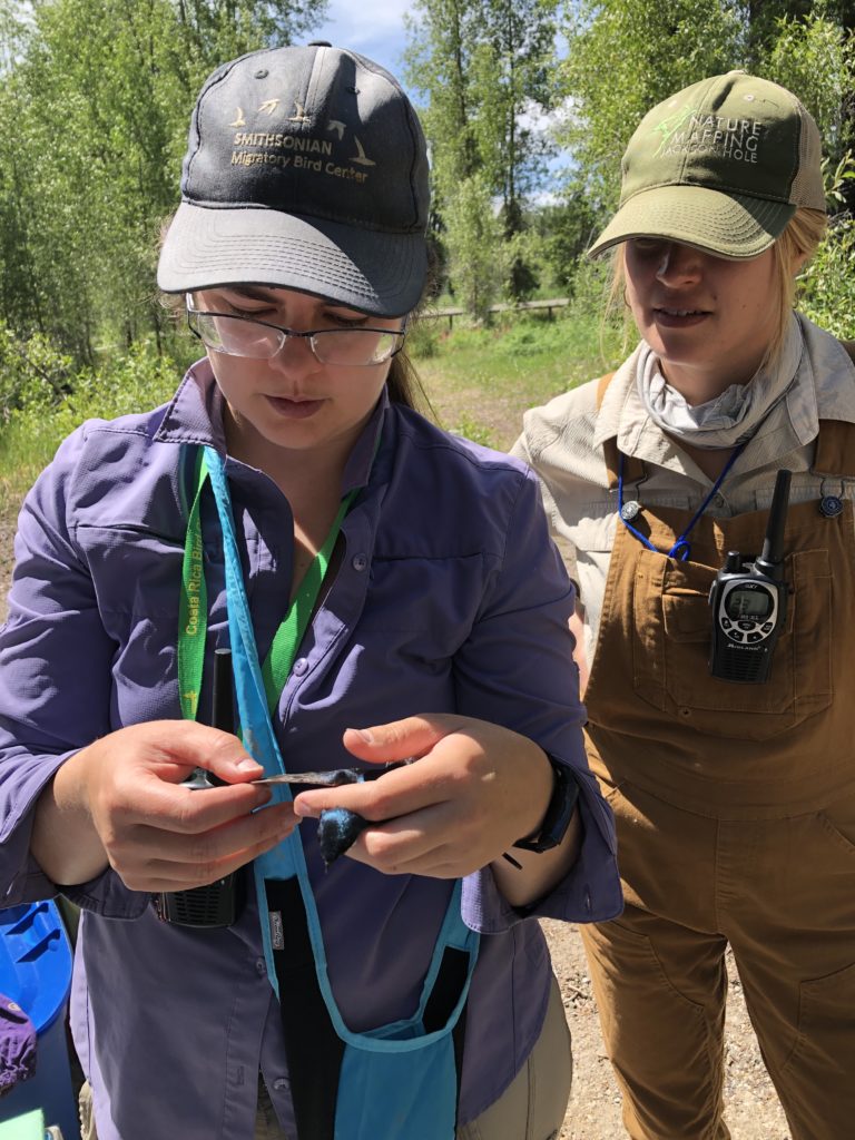
This year, Vicki Morgan and Kevin Perozeni will head up our MAPS bird-banding stations at Boyle’s Hill and the Kelly Campus of the Teton Science Schools. Vicki will be returning for her third summer in a row, while Kevin will be joining us for the first time!
Vicki Morgan – After graduating from the University of North Carolina at Asheville with a B.S. in Ecology and Evolutionary Biology, Vicki Morgan has been working as a roaming biologist and bird bander across the United States. Her past wildlife-related jobs were in areas such as South Carolina, Illinois, American Samoa, Washington DC, NYC, Maryland, and Montana, where she studied and banded birds ranging from hummingbirds to hawks. Vicki has been an avid birder from a young age, and she also enjoys expressing her love of nature through art (fun fact: Vicki actually Minored in ceramics). Vicki spent the winter in Colorado and is returning for her fourth season as Lead Bird Bander with JHWF.
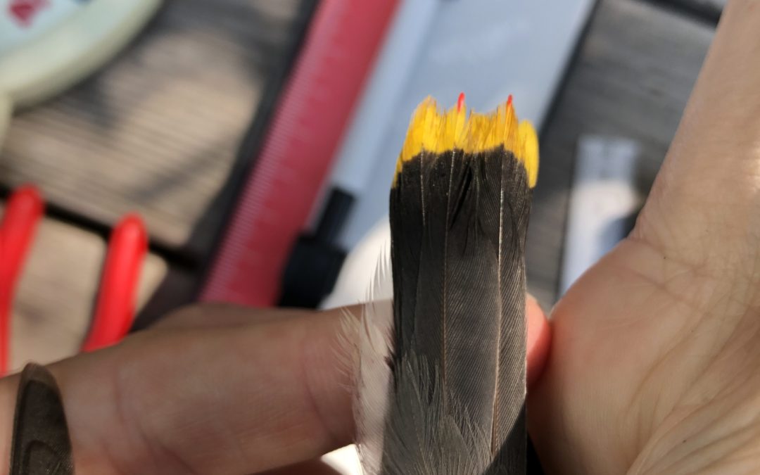
Vicki Morgan figures out the age of a Tree Swallow captured in a mist net last summer.
Kevin Perozeni – Kevin’s educational background includes graduating with honors research with a Bachelor of Science from The Ohio State University, majoring in Forestry, Fisheries and Wildlife. His research thesis involved studying the survival of wintering birds in an increasingly changing urban environment. Since graduating last year, Kevin traveled across the country to work in a variety of field positions. He conducted bird banding at Powdermill Nature Reserve, Pennsylvania as well as banding in Cape May, New Jersey. This fall Kevin will enter a graduate program at LSU, where he will be researching lasting hurricane impacts on avian and forest communities. Kevin also has experience working as a Naturalist within the Cleveland Metroparks, supporting public outreach and education. In his free time, he can be found birding or storm watching, always scanning the skies for all the new experiences that nature consistently brings! Kevin is excited to hold the position of Assistant Bird Bander with JHWF this summer.
An Ohio native, we couldn’t be more excited to welcome Kevin and his wealth of experience to the JHWF team in 2023!
What a great time to be out traveling between Victor Idaho and Farson Wyoming! On Friday, a beautiful sunny spring day, wildlife was on the move and easily seen from the road. My wildlife sightings list in one short day included large groups of elk, mule deer and pronghorn, bighorn sheep, sandhill cranes, vultures, prairie dogs, burrowing owls, bluebirds, and light-colored slatey male Northern Harriers. Enough to give me a grin for days! And lots to report to our Nature Mapping database. 😊
This drive also elevated my vivid awareness of how dangerous this time of year can be for animals moving toward summer range and it reminded me of the work and collaboration we are doing to protect this precious resource. Some updates that may interest you:
In December 2020, at the behest of the Wildlife Foundation and others, the Board of County Commissioners added a statement to the County Transportation Plan that requires a county planning process for WY 390 as a whole corridor. This highway is challenging to mitigate in part due to the dense development and number of access roads. By planning for mitigation at a ‘corridor’ level, the county can move past piece-meal mitigation efforts that have been employed in the past (which have been helpful, in bits and pieces) and create an inclusive plan that makes sense for motorists and wildlife for the length of the roadway. We celebrate this milestone and we look forward to working with the county to create the safest plan for all who live and drive along WY 390 that also preserves and improves habitat for native wildlife that need the “West Bank” to survive.
On the topic of WY 390, our 4 fixed radar signs will be replaced this summer, and an additional radar sign will be added for southbound traffic where the speed limit decreases from 55 to 45 mph. WYDOT has also been scheming additional signs for either end of the corridor that are larger with multiple species represented. These will be similar to other wildlife signs in the county on US 191 and 89.
Planning and design for wildlife crossings at the WY 22-390 intersection is moving along. Construction is slated to begin late 2022 – early 2023. In a similar time-window, the Stilson parking lot is undergoing planning for expansion by JHMR and Teton County. This important work aims to preserve the greater ecosystem by expanding public transit. We are engaging with the county and partners to ensure that wildlife movement in this critical location is not compromised along the way.
A recent federal project was approved to plan for improvements of WY 22 on Teton Pass. This, along with the Stilson plan and another federal project—the BUILD grant— aim to seamlessly tie traffic, transit, and pedestrian flow together from The Village to Driggs, Idaho. We remain vigilant to the process to safeguard wildlife needs for habitat and movement.
Good research continues to help us adaptively improve wildlife crossing structures. Colorado DOT just released results from a study of ~5 years of monitoring over 10 miles of highway mitigation. You may find some of the results interesting…
• Wildlife-vehicle collisions were reduced by 92% where mitigation was installed
• Round-bar wildlife guards (similar to cattle guards) were the best at deterring wildlife breaches
• Elk—a notoriously challenging animal to mitigate for—took 4 years to begin using the structures
Data from our very own South US 89 mitigation is now being processed by the University of Montana. Researchers there are processing wildlife-vehicle collision data, carcass information, and trail camera data collected by a broad partnership, including JHWF, WYDOT, Game and Fish, Teton Conservation District, Greater Yellowstone Coalition (GYC) and others. We hope to see preliminary results that delve into crossing structure use with and without funnel fence as well as any long-term concerns about wildlife deviating from the mitigation and crossing the highway surface at fence ends. These results will help direct any adaptive management needed to make the crossings as effective as possible.
We were just awarded seed money from the Community Foundation’s Youth Philanthropy Program (thank you Youth Philanthropists!) to launch a social media marketing campaign that will provide messaging around safe driving for wildlife in Teton County. The advertisements will include messages like local statistics and safe driving tips for locals, commuters, and visitors.
Finally, stay tuned for a JHWF-GYC-JHCA hosted speaker series that will dive into some of the wildlife-road mitigation that is in planning stages and/or has been proposed for various problem roads around the county. In our first meeting, we plan to talk more about ElectroCrete, which may be tested at fence openings along pathways adjacent to wildlife mitigation.
Thank you for your support and, as always, if you’d like to learn more please reach out to us!