by jhwildlife | Jul 12, 2017 | Blog, Nature Mapping Jackson Hole
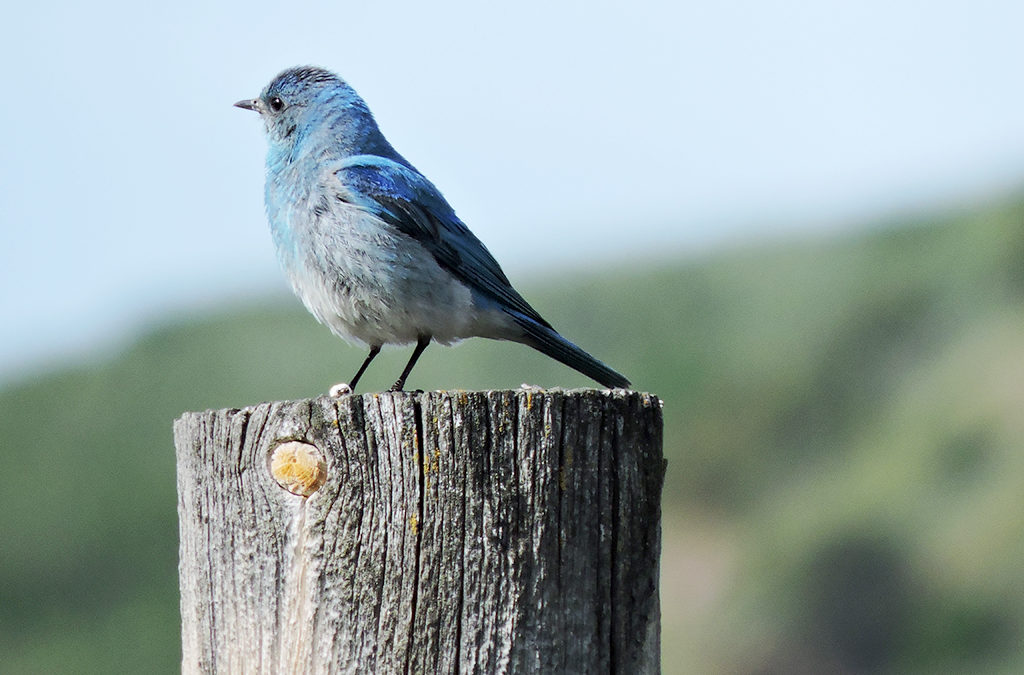
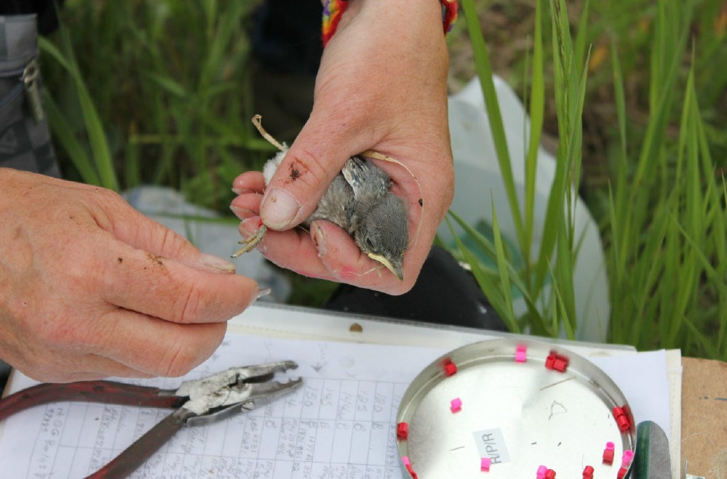
As one leaves the town of Jackson and heads north on HWY 89, a trail of nestboxes lines the fencing of the National Elk Refuge. These nestboxes are part of JHWF’s Mountain Bluebird Nestbox Monitoring Project, which is designed to mitigate for extreme habitat loss that has negatively impacted the breeding success of this species. Monitoring work has been conducted for the past 13 years, but this summer we added a new element to the project by hiring bird bander Allison Swan. With help from our volunteers, Allison has banded 98 chicks and 1 female adult since May.
With data collected through banding and the re-sighting of individuals, we will be able to evaluate survival rates of young, dispersal patterns, re-nesting rates, productivity by age, site fidelity, and other measures of population dynamics. This type of information will allow us to understand population status in Jackson Hole and to better inform land management decisions with respect to the Mountain Bluebird.
Almost all chicks born this summer have fledged their nests and now is the time to begin searching for our color-banded birds — 99 in total.
Already several banded birds have been re-sighted through the use of binoculars and spotting scopes. Our first sighting was a juvenile Mountain Bluebird who crossed the highway and was seen in the parking lot of the National Museum of Wildlife Art. Fledglings can fly quite well, but many are still being fed by the adults, which means they will often stay in place long enough to get a good look at colored-bands on their legs.
All Nature Mappers, we need your help re-sighting banded bluebirds! The most important data we need collected is location data and the color band scheme for each bird. Ideally, we would also like to collect additional data on behavior, substrate and plumage.
The color bands are noticeable and folks have been reporting that it is easy to read the colors, especially with use of binoculars. If you do not have binoculars, please stop by the Jackson Hole Wildlife Foundation office and borrow a pair! We have three scopes and two pair of binoculars for volunteers to borrow while conducting observations.
Download our Re-sighting Datasheet here. As you observe and record sightings of this year’s birds note each ones unique color combination. Datasheets should be given to our Associate Director, Kate Gersh at: Kate@jhwildlife.org. We also encourage the sharing of verbal reports by calling our office at: (307) 739-0968.
Thanks for the help!

by jhwildlife | Jun 22, 2017 | Blog, Nature Mapping Jackson Hole
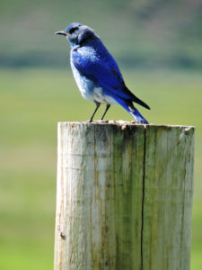 Over the past several weeks, a unique situation was unfolding along our Mountain Bluebird Nestbox Monitoring Trail here in Jackson Hole. Thanks to a serious winter, flooding occurred in our area from fast melting, high altitude snow. Historic flood levels not witnessed in decades. On a Mountain Bluebird trail of 110 nestboxes, several north of town were underwater for weeks, but fortunately those boxes were empty. However, one box — Box #4 — managed to stay just above the flood waters and it held four baby chicks inside. As the Gros Ventre River continued to flow fast and furiously, these hatchlings grew older and days closer to fledging their nest. This posed a great conundrum for the staff of JHWF… .
If the chicks were to fledge into water they would inevitably die. We wondered if anyone had had success with moving a nestbox with chicks inside? We thought about trying to move the box down 75 yards south to dry land. These hatchlings would still need tending to by parents so our hope would be that disturbance wouldn’t cause them to abandon their chicks if the nestbox was moved to a nearby location. Our other option was to let nature take its course; although that felt a bit tough since we’re accountable for installing an artificial nesting cavity. JHWF’s nestbox monitoring project is supporting breeding success as a mitigation effort for habitat loss throughout the Mountain Bluebirds’ range. With only good intentions in mind, either decision we made, came bearing a level of responsibility. In thinking that we could give the chicks in Box #4 a fighting chance to survive, we set about on a relocation mission.
In recent days flood waters have receded! We’ve taken HUGE sighs of relief because our attempt to move the nestbox was unsuccessful due to tricky conditions navigating through water and muck. Three days ago, one of our volunteers saw two “unbanded” fledglings just south of Box #5. These birds must be from Box #4 because all other chicks on our Trail have been banded as part of the larger research project. An adult with food was also onsite yesterday. We choose to assume that the other two chicks also fledged to dry ground. When they finally fledge the nest, Mountain Bluebird chicks have all their flight feathers and it’s possible for them to fly at least 100 yards to start. Although, it’s well documented that they choose to drop to the ground first and stay there for a while. Somehow these chicks figured out that they needed to get distance on those wings right away. Fly on little bluebirds, fly on!
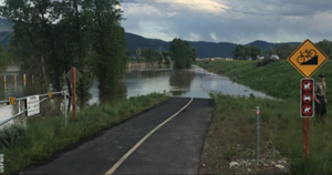
Photo: US Fish & Wildlife Service
by jhwildlife | Jun 15, 2017 | Blog, Nature Mapping Jackson Hole
Since 2003, Nature Mapping Jackson Hole volunteers have monitored 104 Mountain Bluebird (MOBL) nestboxes along the National Elk Refuge (NER). Over the course of many years the loss of standing aspens, cottonwoods, and other riparian vegetation due to thousands of browsing elk has meant the loss of nesting habitat for cavity-dwelling birds such as, the Mountain Bluebird. Historically, bluebirds depend on nest sites in decaying trees and on nesting cavities excavated by woodpeckers and other bird species. JHWF’s Mountain Bluebird Nestbox Monitoring Project is designed to mitigate for this habitat loss by providing artificial nest cavities to support breeding.
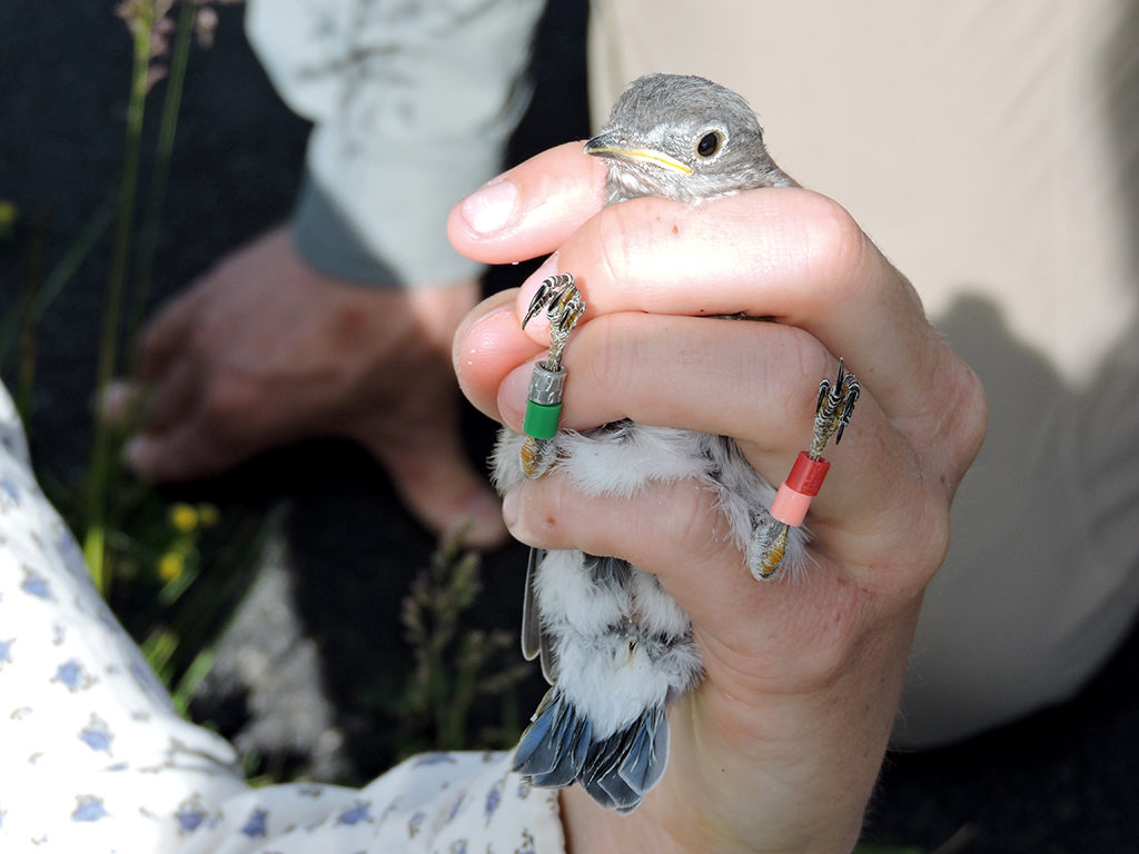
A new addition to the monitoring project this summer, our volunteers will have the opportunity to monitor a total of a 110 nestboxes, and see what happens to the birds after they leave the nestbox by banding nestlings and collecting data on their activity post-fledge. JHWF has secured a Chapter 33 permit from the Wyoming Game & Fish Department for scientific research and hired bird bander Allison Swan (in collaboration with the Teton Raptor Center) to execute the banding program.
WGFD Chapter 33 Permit. Maybe JHWF’s first!
Banding birds provides critical data for demographic studies and the management and conservation of those populations. We know with certainty that habitat loss has played a role in declining populations of Mountain Bluebirds, but we aim to learn if and how other factors have affected this species. Hence, it is important for us to collect data via banding to evaluate survival rates of young, dispersal patterns, renesting rates, productivity by age, and other measures of population dynamics. This type of information will allow us to see how the birds have been faring in Jackson Hole and to ascertain land management options with this species in mind.
NOTE: Banding is completed quickly and does not hurt the birds!
Stay tuned for more news from the field as the summer progresses and baby birds take to the skies!
About Allison Swan:
A Wyoming native, Allison Swan is a graduate of The Evergreen State College with a BA/BS dual degree in ecology and ornithology. She has abundant experience working at Monitoring Avian Productivity and Survivorship (MAPS) stations with students and volunteers, as well as conducting ecological research on focal species. As a student and research fellow, she conducted ecological research on Pacific Wrens throughout the non-breeding and breeding seasons. She has also worked on a number of research projects including, songbird ecology in the rainforests of the Olympic Peninsula, breeding seabirds in Puget Sound, raptor surveys and raven telemetry in sagebrush country. When she’s not banding birds, she enjoys hiking, biking and spending time in the outdoors with her dog, Boulder.
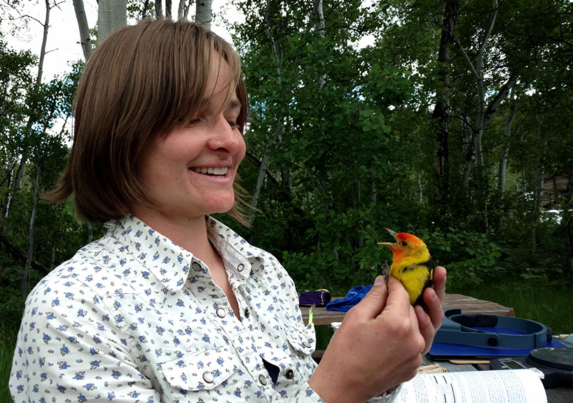
Allison Swan banding a Western Tanager in Jackson Hole – June 15, 2017.
Photo credit for the banding photo on the Blog Page: Ellis Bird Farm
by jhwildlife | Jun 1, 2017 | Blog, Nature Mapping Jackson Hole
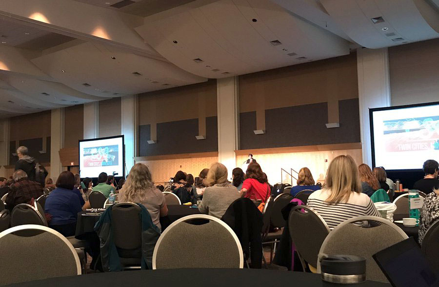
 Last month, JHWF’s Executive and Associate Directors attended the biannual meeting of the Citizen Science Association (CSA) in St. Paul, MN. The CSA aims to bring together the expertise of diverse practitioners working in the field of citizen science, to share the breadth of resources and best practices found throughout the field. Only a few years old, CSA’s membership already exceeds 4,000 individuals from over 80 countries. Indeed, there was a welcomed international contingent in attendance at this gathering of “citsci folks” – Brazil, New Zealand, England, Canada, Australia and Kenya, to name a few.
We came home with our heads full of ideas for our very own Nature Mapping Jackson Hole program, which is a super example of citizen science in action. Conversations at the conference covered many critical areas, such as: the need for fostering community amongst citizen science professionals, a sense of creating a mandate around using well-vetted knowledge to make a difference, advancing the role of public citizens in conducting and defining research, and most of all, fostering and strengthening partnerships across the board.
Best of all, we came back from this conference with a reconfirmation of the value and specialness that is Nature Mapping Jackson Hole. Within the past nine years, 435 people have been trained as certified Nature Mappers and have entered 45,345 observations into the program’s central database. All this effort is filling wildlife observation and distribution needs not already covered by state and federal agencies or local research organizations. Furthermore, together we are fostering a community that looks deeper into the meanings of science and citizenship – therefore, realizing that to participate in the building of knowledge about how our world works, can have profound implications for the way we, Jackson Hole, relate to our natural environment and shape its future.
Thank you for getting involved in the experiences of seeing, feeling, and understanding nature in all its amazingness through Nature Mapping Jackson Hole. Keep up the great work, it’s making a difference!
The whole of science, and one is tempted to think the whole of the life of any thinking man, is trying to come to terms with the relationship between yourself and the natural world. Why are you here, and how do you fit in, and what’s it all about?
– Sir David Attenborough
by jhwildlife | May 19, 2017 | Blog, Wildlife Friendlier Landscapes
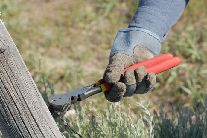
Please join us Saturday, June 3 at Buffalo Valley Swan Pond, Bridger-Teton National Forest to volunteer to help with the removal of barbed wire and smooth wire fences.
Project Details
For our first public project of the year, we plan to remove .5 miles of barbed wire and smooth wire fencing in prime wildlife habitat in the Buffalo Valley. The work area is scenic and the terrain is flat and easily traversed. This project assists our partners at Bridger-Teton National Forest as they aim to make important habitat more permeable to wildlife movement.
The project is average in difficulty (3 on a 1-10 scale).
We will meet at two car pool sites:
- Home Ranch Parking Lot (north side) at 8:15 a.m.
- Gros Ventre Junction at 8:30 a.m.
We will carpool from these sites to the project. We plan to work from 9 a.m. to 2 p.m. and half-day (morning) is welcome, as well. We will provide water, Gatorade and snacks. Please bring your own water bottle or hydration packs. We will take a mid-day lunch break so please bring your own lunch.
Gear: You should wear layered clothes, long pants, sturdy shoes, and bring a rain jacket in case of storms. Sun or eyeglasses are a MUST for working with barbed wire. Sun protection (hat & sunscreen lotion) is also recommended, and will hopefully be necessary! We also recommend that volunteers check the status of their tetanus shots, in case of scratches from the old fencing material. We will provide work gloves and tools.
Please RSVP to jhwffencepull@gmail.com if you plan to attend and let us know at which car pool site you will join us (1 of 2 locations listed above). You can also send questions to this same email address. Additional last-minute information on this event will be posted here.
See you on June 3!
by jhwildlife | May 10, 2017 | Blog, Give Wildlife a Brake
On Saturday, April 29, representatives from the Greater Yellowstone Coalition, Jackson Hole Conservation Alliance and Jackson Hole Wildlife Foundation joined Wyoming Game & Fish Department (WGFD) Wildlife Biologist Gary Fralick to survey winter deer mortality along Highway 89 south of Jackson. None of the participants could have envisioned witnessing an event that brought the poignancy of the wildlife-vehicle issue into vivid focus, but within minutes of starting the survey, they experienced an emotional interaction with one of this winter’s latest casualties.
Fralick led the targeted survey of a half-mile stretch of South Highway 89 from the Snake River Bridge at Von Gontard’s Landing north to Game Creek Road. As a group of six individuals swept through a cottonwood stand on the east side of the highway, they encountered a mule deer doe laying in the underbrush. As the group approached, the deer struggled mightily to flee but couldn’t get to its feet. Its back legs had clearly been broken in a collision with a car. How long it had been suffering there is anyone’s guess, but with the specter of starvation a certainty for an animal with two broken legs, Fralick acted quickly to humanely put the animal out of its misery.
This encounter really struck home for our participants and for Gary himself. All of our organizations recently attended the Wyoming Wildlife and Roadways Summit in Pinedale, which highlighted the biological and engineering considerations in mitigating the impacts of our roads on wildlife and increasing human safety. But this is the side of wildlife vehicle collisions (WVCs) that often goes unseen and is truly tragic. This prime age class doe deer had made it through the difficult winter we had and would likely have survived and helped the population rebound. We also witnessed a side of WVCs that only WGFD wardens and biologists and Wyoming Department of Transportation (WYDOT) highway patrol have to participate in and that is the always difficult reality of dispatching an animal, along a busy highway, something that really can never become easy, even for these trained professionals.
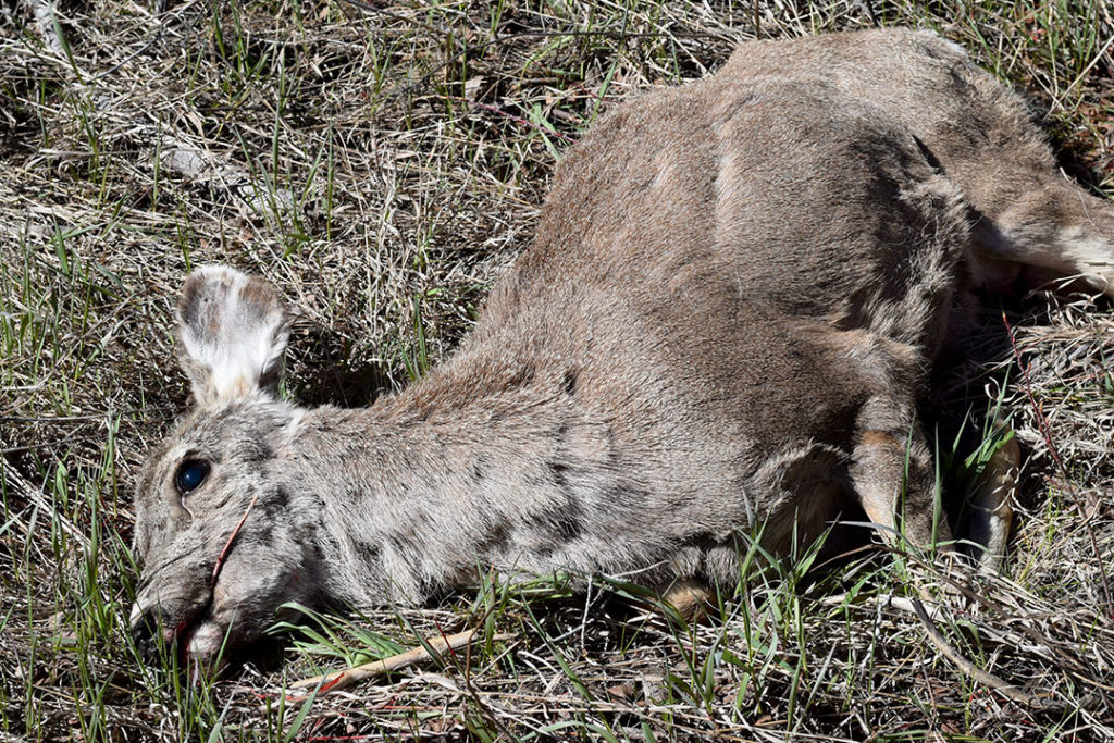
Mule deer doe moments after it was put down.
In reality, the life of that deer ended the moment it was struck by a vehicle. As is often the case, an injured animal struggles to its final resting place well off the shoulder of the road, where it may suffer for weeks until it starves to death. The collision may not have even been reported if it hadn’t caused sufficient damage to the vehicle. Studies have shown that up to one-half of deer vehicle collisions go unreported, so the impacts of wildlife-vehicle collisions are actually far greater than the reports on which we base a lot of our decisions.
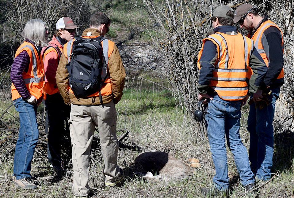
Survey participants, moved by the power of the moment, mourn the loss of a deer that almost made it through a rough winter.
A few hundred yards from that tragic scene, the group encountered a pair of White-tailed deer carcasses that succumbed under the Flat Creek Bridge, likely after having been struck by vehicles. Those two deer, which died weeks apart in February, incidentally had images captured by a remote-sensing camera that had been placed under the bridge to study the movements of wildlife. Watching the prolonged suffering and eventual death of those deer through time-lapse photography is no easier than witnessing it first hand.
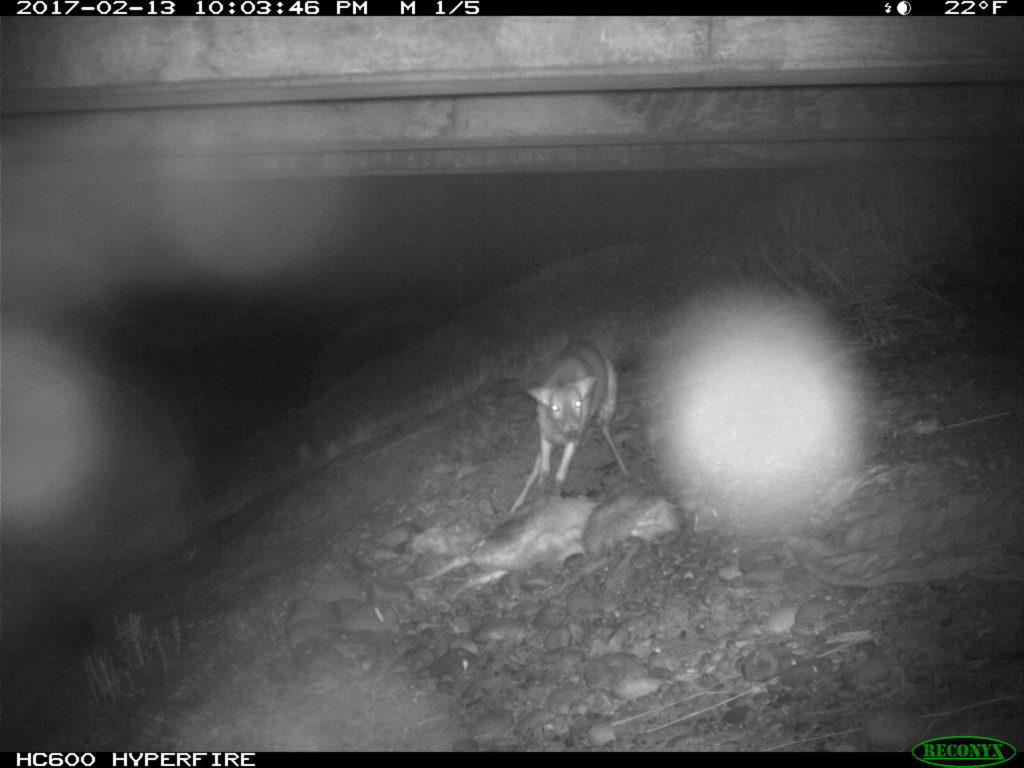
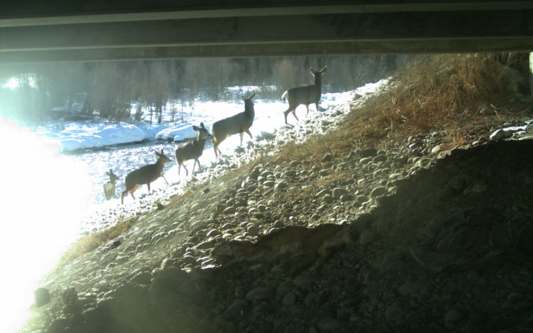
Starting in 2015, several local and regional organizations (Center for Large Landscape Conservation, Greater Yellowstone Coalition, Jackson Hole Wildlife Foundation, Jackson Hole Conservation Alliance, Teton Conservation District and Yellowstone to Yukon Conservation Initiative) began working in collaboration with WYDOT to provide pre-construction monitoring of proposed future wildlife crossings along South Highway 89/191 using remote camera sites at locations identified for their importance for connectivity in a future highway redevelopment project that will begin in 2017.
WYDOT is building six large underpasses and many smaller structures to facilitate wildlife movement, reduce wildlife-vehicle collisions, and improve highway safety. The remote cameras are monitoring the proposed locations.
Those underpasses will facilitate safe passage for deer, elk and moose as well as many smaller animals upon completion. The construction of these structures is starting this summer. Studies suggest underpasses are 80%-90% effective at reducing wildlife-vehicle collisions.
The group conducted the targeted survey to collect data that will contribute to WGFD’s knowledge about the mule deer that winter in and around the town of Jackson. Tooth samples were extracted and fibula marrow assessments were conducted on the spot to ascertain age and relative health, or body condition of the animal when it died. The group surveyed a total of one mile – a half-mile on each side of the highway. Within that stretch, 10 carcasses were observed in the ditches and wooded areas along the road underscoring the impacts of this winter on deer throughout the valley, and WVCs on this stretch of South Highway 89.
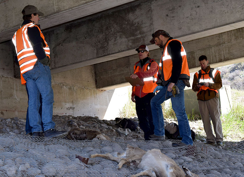
One of the last carcasses we encountered was a very old age-class doe, with a broken hind leg, wearing an eartag. We’re waiting on the results, but the tag likely came from a study looking at local movements and migrations across our roads. During that study, completed by Teton Science Schools, highway collisions was the number one source of mortality for collared deer. Since the collars have fallen off to allow researchers to collect the data stored within them, it is important that this eartag was retrieved and unsurprising that the individual was killed by a car in this stretch of road years after the study was complete.
Thankfully, construction is about to begin on the first series of underpasses on South Highway 89 and much of the carnage the group encountered on its short survey will be reduced or nearly eliminated in the near future on that stretch of highway.
In 2016, WYDOT, WGFD and local citizens recorded a total of 335 wildlife mortalities on Teton County Highways outside of Grand Teton National Park. This trial winter deer mortality survey illuminated the fact that the actual number of mortalities is likely 25%-50% higher, and it also instilled in the participants a reminder that wildlife deaths caused by vehicles often include a long, painful demise out of our view.
As construction begins on some of the first of our wildlife crossing structures in Jackson Hole, we are also grateful that Teton County is looking at its entire network of roads as it completes a wildlife-roadway master plan with the help of experts at Western Transportation Institute. Many organizations and agencies continue to discuss site-specific solutions to eliminate scenes like those witnessed on the winter deer mortality survey. All options are considered with the knowledge that various mitigation measures may be needed to address some of the complexities of Teton County’s land and roadway system.